The recent disruption in the Strait of Hormuz highlights how global trade is critically dependent on a handful of narrow maritime chokepoints that carry a disproportionate share of energy and commodity flows.
Escalating Crisis And Structural Vulnerability
- Immediate trigger in West Asia: The conflict involving Iran has led to the effective closure of the Strait of Hormuz, with more than a dozen ships attacked in a span of two weeks. The crisis intensified after US and Israeli airstrikes across Iran, marking the most serious escalation in decades.
- Geopolitical pressure and global stakes: The United States has urged European allies to support reopening the strait, warning of consequences for NATO cohesion, while Iran has signalled its intent to keep the waterway closed.
- Economic shock and market reaction: Brent crude prices surged sharply from around $70 per barrel before the crisis to above $100, and at peak levels crossed $126 per barrel, reflecting the scale of supply disruption.
- Broader systemic concern: Beyond the immediate crisis, the episode underscores a deeper structural issue—global trade depends on a very small number of maritime chokepoints, making it highly vulnerable to geopolitical shocks.
Strait of Hormuz As The Most Critical Energy Chokepoint
Geographical setting and physical structure
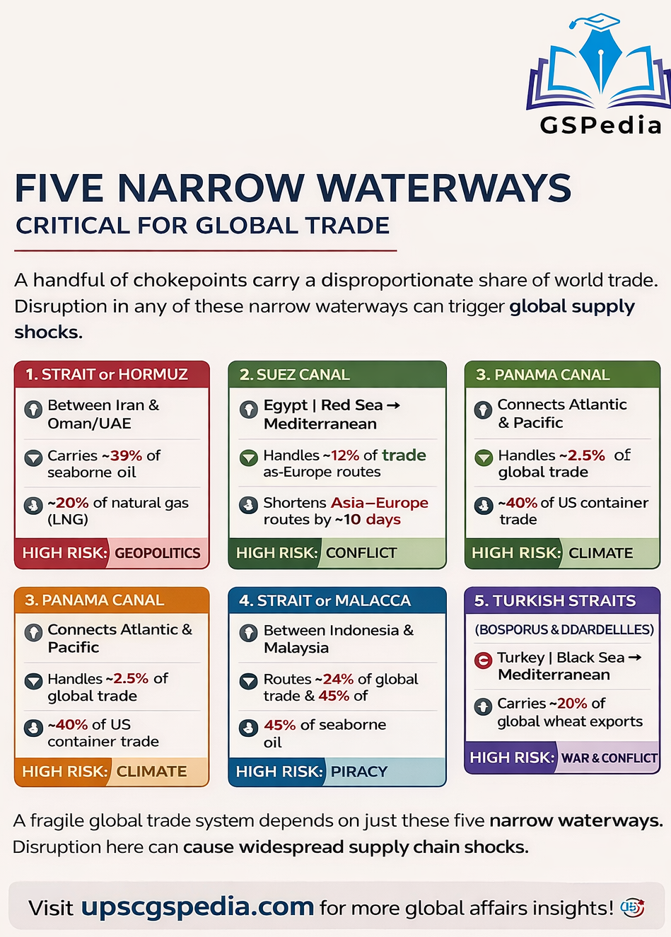
The Strait of Hormuz is a 167-kilometre waterway connecting the Persian Gulf with the Gulf of Oman and the Arabian Sea. It is bordered by Iran to the north and Oman and the United Arab Emirates to the south.
The strait is about 90–100 miles long and narrows to approximately 33–39 kilometres at its tightest point, located between Iran and the Omani Musandam Peninsula. It serves as the only maritime outlet for the Persian Gulf.
Navigation system and legal regime
Shipping in the strait operates through a Traffic Separation Scheme (TSS), with inbound and outbound lanes each about 3.2 kilometres (two miles) wide, separated by a two-mile buffer zone. These lanes lie within Iranian and Omani territorial waters; however, international law guarantees the right of transit passage for all vessels.
Depth and navigational capacity
The strait has a depth ranging from approximately 60 to 100 metres, which is sufficient to accommodate very large crude carriers (VLCCs), enabling the passage of some of the world’s largest oil tankers.
Strategic islands and control
Iran controls several strategically important islands within the strait, including Qeshm, Hormuz, Larak, Hengam, and the Greater and Lesser Tunbs and Abu Musa. These locations provide vantage points for monitoring and influencing maritime traffic.
Scale of energy flows
The strait carries approximately 39% of global seaborne crude oil trade and about 19–20% of global natural gas and LNG shipments, including exports from Qatar. Nearly 20% of total global oil consumption—around 20 million barrels per day—passes through this route, making it the world’s most critical energy chokepoint.
Absence of viable alternatives
There is no effective alternative maritime route for Gulf countries to export energy, making the strait uniquely indispensable for global energy supply chains.
Wider trade and economic significance
Beyond energy, the Gulf region handles over 26 million containers annually, and major fertiliser exports also pass through the strait. This connects it directly to global manufacturing, agriculture, and food production costs.
Impact of disruption
Any disruption or closure of the strait has severe consequences. The ongoing closure represents the largest oil supply disruption in history, with cascading effects on global energy markets, commodity prices, and supply chains. Regional hubs such as Dubai and Abu Dhabi depend heavily on this route for essential imports, further amplifying its economic significance.
Suez Canal And Bab el-Mandeb As A Combined Vulnerability
Geographical linkage and route efficiency
The Suez Canal is a 193.3-kilometre artificial sea-level waterway in Egypt connecting the Mediterranean Sea with the Red Sea. It runs north–south across the Isthmus of Suez, effectively separating Africa and Asia.
The canal provides the shortest maritime route between Europe and Asia, reducing travel time by at least ten days and cutting distance by about 40% compared to the Cape of Good Hope route, avoiding a detour of 6,000–9,000 kilometres.
Unlike the Panama Canal, it operates without locks due to nearly identical sea levels. Its route incorporates natural lakes such as Lake Manzala, Lake Timsah, and the Bitter Lakes, with the Nile delta to the west and the Sinai Peninsula to the east.
Trade volume and cargo profile
The canal handles about 10–12% of global seaborne trade. It carries approximately 22% of global container traffic, 20% of car shipments, and around 10% of crude oil flows, making it a critical artery for global commerce.
Critical southern chokepoint
The Bab el-Mandeb strait at the southern entrance of the Red Sea represents a major vulnerability. Disruptions in this narrow passage directly affect traffic through the Suez Canal.
Impact of Red Sea insecurity
Between 2023 and 2025, attacks by Iran-backed Houthi groups on shipping in the Red Sea forced companies to reroute vessels around Africa. This diversion increased journey distances by approximately 9,000 kilometres and significantly disrupted established trade routes.
Collapse in traffic
As a result of these security disruptions, vessel traffic through the Suez Canal declined sharply from over 26,000 ships in 2023 to around 13,000 in 2024.
Illustration through accidents
The Ever Given incident in 2021 highlighted the canal’s structural vulnerability when a single vessel blocked the waterway for six days, disrupting nearly $10 billion worth of trade.
Current operational dynamics in 2026
The canal is experiencing only a partial recovery in traffic. On March 15, 2026, a total of 39 vessels transited the canal, marking a 69% increase from the previous day but still remaining below historical averages.
Adaptive shipping strategies
Major shipping companies such as Maersk, Hapag-Lloyd, and CMA CGM have adopted a hybrid strategy, routing urgent cargo through the Suez Canal while diverting other shipments around Africa due to ongoing security risks.
Energy and food security role
The canal continues to play a vital role in global grain trade, especially flows from Europe and Ukraine, as well as in oil and LNG transit. Its importance has increased further as energy flows shift westward in response to disruptions in other chokepoints such as Hormuz.
Panama Canal As A Strategic Alternative Route
Geographical role and connectivity
The Panama Canal is an 82-kilometre artificial waterway that cuts across the Isthmus of Panama, connecting the Atlantic and Pacific Oceans. It serves as a critical inter-oceanic shortcut, allowing ships to bypass the long route around the southern tip of South America and saving approximately 13,000–15,000 kilometres in travel distance.
The canal’s path follows a northwest to southeast direction due to the S-shaped geography of the isthmus. Its Atlantic entrance is near Colón, while the Pacific exit is near Balboa, close to Panama City.
Key geographical features
A central feature of the canal is Gatún Lake, an artificial freshwater lake located about 26 metres above sea level, created by damming the Chagres River. It acts as a water bridge enabling ship transit. Another critical section is the Culebra Cut (Gaillard Cut), an 8-mile trench carved through the continental divide, representing the most challenging segment of the canal.
Trade share and cargo concentration
The canal handles about 2.5% of global trade, with a concentration of high-value cargo such as containerised goods, automobiles, and grain. Its role is particularly significant in facilitating efficient inter-coastal and intercontinental trade flows.
Significance for the United States
The canal is vital for the United States, with around 40% of its containerised trade—valued at approximately $270 billion annually—passing through this route.
Climate-induced vulnerability
The canal’s operations depend entirely on freshwater from the surrounding rainforest watershed. Each transit consumes roughly 52 million gallons of freshwater, which is lost to the sea. Severe droughts during 2023–24 reduced water levels in reservoirs such as Gatún Lake, forcing restrictions on vessel size (draft limits) and the number of daily transits.
Environmental and operational challenges
In addition to water scarcity, siltation caused by deforestation, heavy rainfall, and landslides leads to sediment accumulation in the channel, requiring continuous dredging to maintain navigability.
Geopolitical concerns
Concerns related to port operations and the possibility of external control have introduced a political dimension to the canal’s functioning, increasing its strategic sensitivity.
Current strategic importance in 2026
Amid disruptions in other major maritime routes such as Hormuz and Suez, the Panama Canal is operating near full capacity, handling approximately 36–38 vessels per day.
Rising energy transit role
There has been a surge in demand from LNG tankers, with plans to increase transit slots to accommodate growing energy flows from the US Gulf Coast to Asia, enhancing the canal’s role in global energy logistics.
Strait of Malacca As The World’s Busiest Maritime Corridor
Geographical characteristics
The Strait of Malacca connects the Indian Ocean with the Pacific Ocean and extends approximately 800–930 km. It lies between the Malay Peninsula (Malaysia and southern Thailand) to the northeast and the Indonesian island of Sumatra to the southwest.
The width varies from about 250 km in the north to just 2.8 km at the Phillips Channel near Singapore. The strait is relatively shallow, with an average depth of around 25 metres.
Global trade and energy significance
The strait carries nearly 24% of global trade and plays a major role in energy transportation, handling about 45% of seaborne crude oil. It also facilitates a significant share of automobile shipments, making it a critical route for international maritime commerce.
Major ports and shipping hubs
The strait hosts major global ports, including the Port of Singapore, as well as Malaysia’s Port Klang and Tanjung Pelepas. These ports function as key nodes for handling and transshipment of global cargo.
Dependence of East Asian economies
Countries such as China, Japan, and South Korea rely heavily on this route for energy imports. Nearly 80% of China’s crude oil imports pass through the Strait of Malacca, highlighting its strategic importance.
The Malacca dilemma
China’s dependence on the strait creates a strategic vulnerability, referred to as the “Malacca Dilemma,” where any disruption could significantly increase costs and disrupt supply chains.
Operational constraints and Malaccamax limit
Due to shallow depth, only ships within the “Malaccamax” category can pass safely through the strait. Larger vessels exceeding this limit are required to divert to deeper alternatives such as the Lombok Strait.
Security risks and piracy
Piracy remains a persistent concern in the strait, with over 130 incidents reported in 2025. In addition, emerging non-traditional security threats continue to pose risks to maritime navigation.
Geopolitical tensions and military buildup
Rising competition among major powers, including China, India, and the United States, increases the risk of disruption. India’s development of infrastructure in the Andaman and Nicobar region reflects growing strategic attention to this corridor.
Natural disaster exposure
The strait is vulnerable to natural hazards such as tsunamis and volcanic activity. The 2004 tsunami demonstrated this vulnerability by damaging infrastructure and affecting maritime operations.
Strategic significance
The Strait of Malacca remains one of the most important maritime corridors globally due to its role in facilitating large volumes of trade and energy flows under constrained geographical and operational conditions.
Turkish Straits As A Strategic Maritime Link
Geographical configuration
The Turkish Straits consist of the Bosporus and the Dardanelles, together with the Sea of Marmara forming the only maritime link between the Black Sea and the Mediterranean Sea. The Bosporus connects the Black Sea to the Sea of Marmara and is about 30 km long, with width ranging from 700 metres to about 3.7 km.
It physically divides Istanbul into its European and Asian parts. The Dardanelles connects the Sea of Marmara to the Aegean Sea and is about 68 km long, with widths ranging from approximately 1.2 km to 6 km. The Sea of Marmara acts as an internal transitional basin between the two straits.
Trade and agricultural significance
The straits carry about 3% of global trade but are critically important for transporting agricultural commodities. Around 20% of global wheat exports from countries such as Ukraine, Russia, and Romania pass through this route, making it essential for global food supply chains.
They also function as a primary trade and energy corridor for Black Sea littoral states, including Russia, Ukraine, Romania, Bulgaria, and Georgia.
Navigation challenges
Navigation through the Bosporus is highly complex due to its narrow width, sharp turns, and dense traffic, especially in the Istanbul section where it narrows to around 700 metres. This leads to frequent congestion and occasional minor collisions, requiring careful traffic management.
Legal framework and control
The straits are governed by the Montreux Convention of 1936, which grants Turkey sovereign control while ensuring freedom of passage for civilian vessels in peacetime. The convention also regulates military access, imposing restrictions on warship passage.
Wartime provisions and current application
Under the convention, if Turkey is not a participant in a conflict, it can restrict the passage of warships belonging to warring nations, except those returning to their home ports.
It also imposes tonnage limits and duration restrictions (maximum 21 days) on non-Black Sea powers. In 2026, Turkey continues to invoke these provisions, particularly in the context of the Russia–Ukraine conflict, limiting warship transits into the Black Sea.
Current operational conditions
The straits remain operational with enhanced safety measures, including one-way traffic during adverse conditions and stricter management of hazardous cargo to reduce risks associated with navigation.
Strategic importance in current crisis
With disruptions in other major chokepoints, the Turkish Straits have gained renewed importance as a relatively stable route for exports from the Black Sea region.
Risk environment
Shipping in the region faces multiple risks, including war-related uncertainties, sanctions, insurance constraints, and physical safety concerns. Additionally, the region’s seismic activity adds another layer of vulnerability to maritime operations.
Wider Network Of Maritime Chokepoints
- Beyond the five key waterways: Globally, there are around 24 maritime chokepoints, including the Taiwan Strait, Dover Strait, and Bering Strait.
- Diverse risk landscape: Each chokepoint faces a unique mix of threats, including geopolitical tensions, piracy, climate change, accidents, and natural disasters.