On April 17, 2026, the Ministry of Jal Shakti made public the Government of India’s decision to continue the River Basin Management Scheme for the period 2026–27 to 2030–31 with a significantly increased outlay of ₹2,183 crore.
The announcement underscores a stronger policy commitment to basin-level planning, scientific water governance, and long-term development of surface water and groundwater resources across strategically important river systems.
Scheme Profile And Policy Shift
- Core Framework: The River Basin Management Scheme is a central sector scheme under the Department of Water Resources, River Development, and Ganga Rejuvenation in the Ministry of Jal Shakti. It is designed as a scientific and institutional framework for the integrated management, protection, and sustainable development of river basins.
- Basin-Level Approach: The scheme shifts water governance away from localized projects and treats entire river systems as a single hydrological unit. This planning framework covers rivers, tributaries, groundwater, and associated ecosystems.
- Period and Outlay: The scheme will continue during the 16th Finance Commission period from 2026–27 to 2030–31. It carries an estimated cost of ₹2,183 crore and is fully funded by the government.
- Expanded Financial Commitment: In the previous phase covering 2021–22 to 2025–26, the total budget allocation was ₹1,276 crore. The revised outlay reflects a continued and increased commitment to integrated water resource planning and development.
River Basin Basics
Rationale For River Basin Management
- Growing Resource Pressure: Water supports ecosystems, livelihoods, agriculture, industry, energy generation, and human well-being. As dependence on water rises across sectors, efficient and coordinated use of the resource has become increasingly important.
- Need for Integrated Planning: Basin-level planning has become essential in the context of floods, erosion, uneven water distribution, and ecological degradation. The scheme seeks to address these interconnected challenges in a structured and scientific manner.
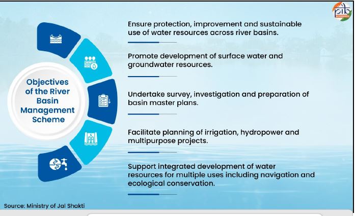
- Sustainable Resource Use: The scheme promotes sustainable use of water while supporting irrigation, hydropower, and flood management. It also supports integrated development of water resources for multiple uses, including navigation and ecological conservation.
- Broader Governance Need: Stronger water governance is also linked to climate variability, rising demand, cross-border river management, drainage stress, and the need for reliable water access in vulnerable regions.
Geographical Focus And Strategic Relevance
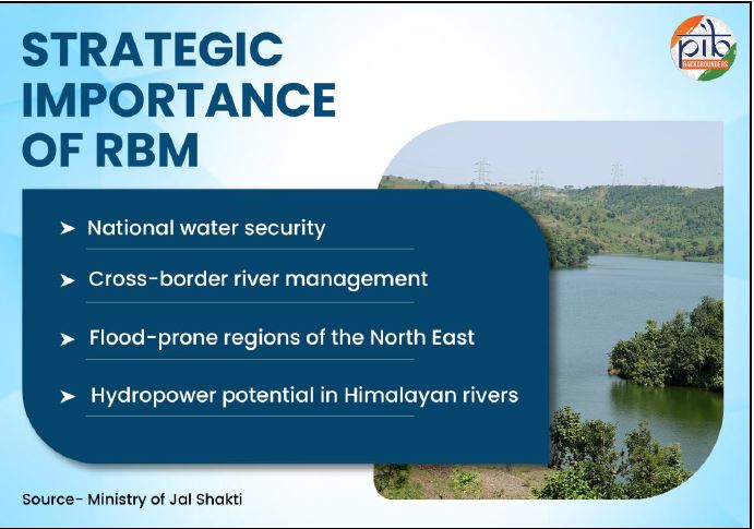
- Priority Regions: The scheme focuses on strategically important and water-rich but underdeveloped regions, especially the North Eastern Region and the Indus Basin in Jammu & Kashmir and Ladakh. Key basins include the Brahmaputra, Barak, Teesta, and Indus.
- Strategic Importance: These basins are prioritized because of their significance for national water security, cross-border water management, flood control, erosion management, and ecological stability. The scheme also supports hydropower potential in Himalayan rivers.
- Support to Capacity-Constrained Regions: The framework addresses capacity gaps in regions such as Jammu & Kashmir, Sikkim, Mizoram, Manipur, Nagaland, Ladakh, and other North Eastern states. It enables these areas to undertake water resource planning despite technical and financial constraints.
Institutional Structure And Implementation
- Implementing Bodies: The scheme is implemented through the Brahmaputra Board, the Central Water Commission, and the National Water Development Agency. Together, these institutions support basin master plans, surveys, project investigation, and multipurpose planning.
- Brahmaputra Board Role: The Brahmaputra Board handles basin-level planning and flood management in the North Eastern Region. Its work includes surveys and investigations, master plan formulation and revision, anti-erosion measures, drainage development, raised platforms in flood-prone areas, springshed-related activities, and capacity building.
- CWC Role: Under the Investigation of Water Resources Development Scheme component, the Central Water Commission undertakes surveys, investigations, and preparation of Detailed Project Reports for projects in the Indus, Brahmaputra, Barak, and Teesta basins. These activities are especially important in remote terrains where logistics are difficult and working seasons are limited.
- NWDA Role: The National Water Development Agency focuses on national-level planning under the Interlinking of Rivers programme. Its responsibilities include preparing Pre-Feasibility Reports, Feasibility Reports, Detailed Project Reports, water balance studies, and plans for inter-basin water transfers.
Key Areas Of Action
- Basin Planning: The scheme provides for the preparation and periodic updating of river basin master plans. These plans serve as long-term roadmaps for development, utilization, and conservation of water resources within each basin.
- Survey and Investigation: Extensive field investigation supports planning and project preparation. This includes drilling, drifting, hydrological surveys, topographical surveys, geological investigation, and collection of primary and secondary data.
- Project Development: The framework supports preparation of Detailed Project Reports for multipurpose projects. It also covers planning for irrigation, hydropower, flood control, erosion management, drainage development, and other systematic interventions.
- Flood and Erosion Management: Special measures are undertaken in vulnerable regions to reduce the impact of floods and riverbank erosion. These include anti-erosion works, structural protection, flood control measures, bio-engineering interventions, and raised platforms for shelter during floods.
- Drainage Development: Drainage development addresses waterlogging and improves water flow in drainage-congested areas. These measures aim to improve land productivity and water management in both rural and urban regions.
- Community-Based Interventions: The scheme supports improved local water use practices, springshed management, water body development, and dissemination of indigenous practices with scientific improvement. These initiatives are especially relevant for rural, hilly, and tribal communities.
Transboundary Dimension of Water Governance
Technical And Developmental Progress
- Basin Studies and Master Plans: During 2021–26, basin master plans were prepared and updated for major river systems in the Brahmaputra and Barak basins. Basin-level studies also supported integrated water resource planning and flood management strategies.
- Project Investigations: Extensive survey and investigation work was carried out across river basins in the North Eastern Region and Himalayan areas. These studies form the basis for future irrigation, hydropower, and multipurpose projects.
- DPR Pipeline: Detailed Project Reports were prepared for multiple projects in the Brahmaputra, Barak, Teesta, and Indus basins. These DPRs were developed for remote and strategically important areas and are expected to enable future investment in irrigation, hydropower, and flood control.
- ILR Progress: Under the National Perspective Plan, the NWDA identified 30 river link projects. Pre-Feasibility Reports were completed for all identified links, Feasibility Reports were finalized for 26 projects, and Detailed Project Reports were prepared for 15 link projects, including the Kosi–Mechi intra-state link project in Bihar.
- Modern Technology Use: Survey and planning have increasingly used GIS, remote sensing, LiDAR, drone-based surveys, and advanced hydrological modelling tools. These have improved the accuracy and efficiency of basin studies and DPR preparation.
Measurable Outcomes And Strategic Gains
- Infrastructure Gains: The scheme has contributed to improved irrigation infrastructure and increased hydropower generation through sustained planning and project preparation. It has also supported better flood and erosion control along with infrastructure development. The infographic on page 10 also highlights these outcomes alongside sustainable water resource management and socio-economic upliftment, especially in the North East and Himalayan areas.
- Protection of Vulnerable Areas: Protection works in places such as Majuli Island in Assam illustrate the scheme’s role in anti-erosion and flood management. The images on pages 7 and 8 show post-construction bank revetment work at Sumoimari and Spur No. 2 at the Salmara Besamara reach in Majuli.
- Continuity of Long-Term Planning: The framework has maintained continuity in basin planning, DPR preparation, flood management works, and future project pipelines. This continuity is important for long-gestation water resource development.
The continuation of the River Basin Management Scheme with a higher outlay signals a stronger national commitment to integrated and scientifically grounded water governance. By linking basin planning, technological tools, infrastructure readiness, institutional coordination, and community-level
UPSC Prelims Quiz
Practice exam-oriented current affairs questions daily and track your preparation effectively.
Attempt Quiz →